

Our Services
We deliver structured, survey-ready environmental data for the Western Australian resources sector. Our services are designed to integrate directly with existing ecological consultancy workflows, reducing field time, compressing processing overhead, and delivering data that arrives at the ecologist's desk organised, georeferenced, and ready for verification.
All work is conducted in accordance with EPA WA Technical Guidance on Vertebrate Fauna Surveys. Ecological sign-off is provided by or in partnership with DBCA-licensed zoologists.
Acoustic & Camera Trap Data Collection
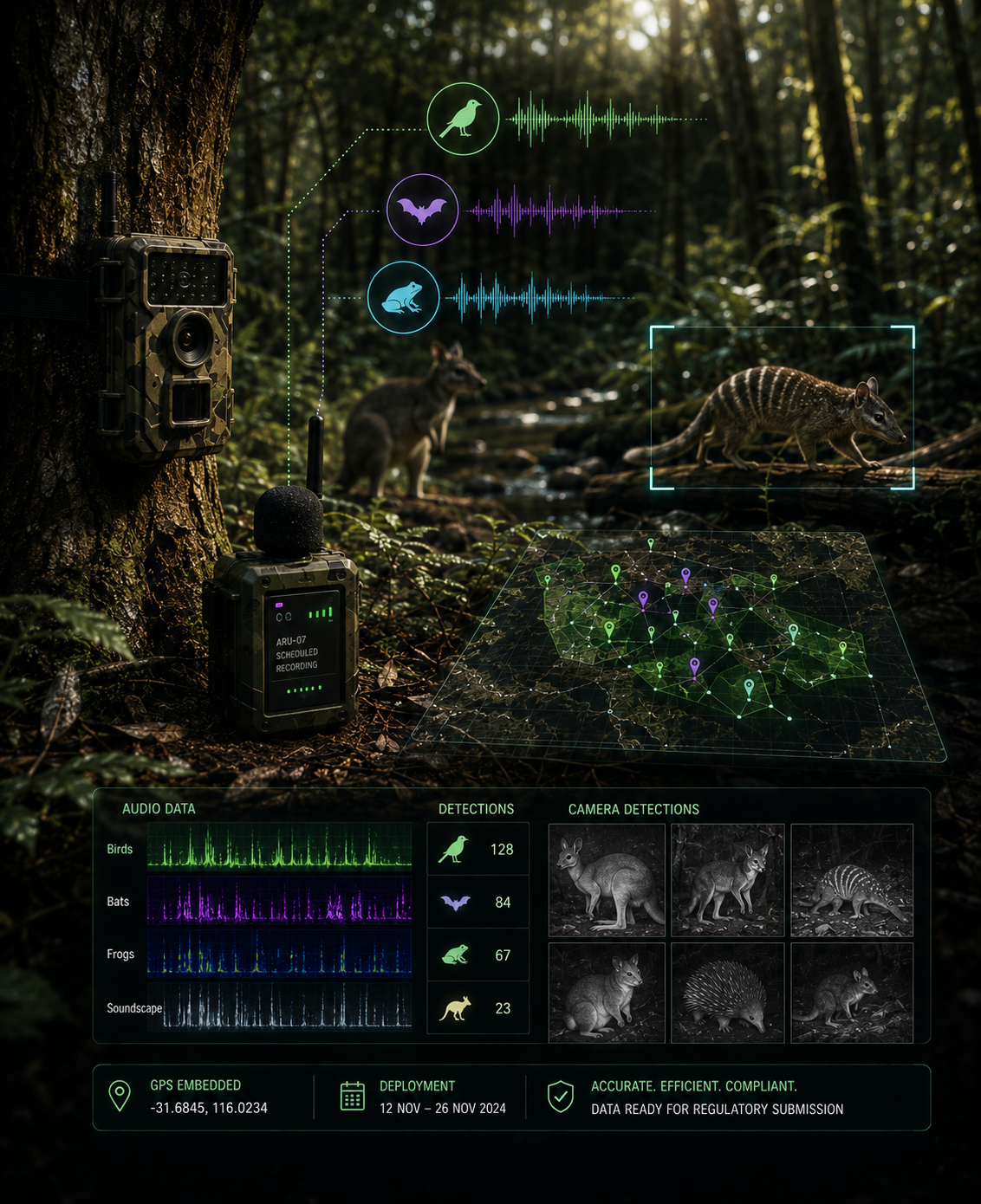
Field-deployed autonomous recording unit (ARU) networks and camera trap arrays form the primary detection layer of our survey methodology.
ARUs are programmed for scheduled and triggered acoustic recording across the survey area, capturing bird vocalisations, bat echolocation calls, frog calls, and broader soundscape data continuously throughout the deployment period. Camera trap arrays provide simultaneous visual detection coverage for medium and large mammal activity.
All units are deployed, monitored, and retrieved efficiently across the survey area, covering ground that would take a ground-based field team significantly longer to reach and service manually. GPS coordinates from each unit are embedded in all data outputs, providing a precise spatial record of every detection for regulatory submission.
Suitable for: Level 1 and Level 2 vertebrate fauna assessments, targeted bat surveys, bird community assessments, mammal activity monitoring.

Drone-Assisted Habitat & Fauna Survey
Drone-assisted data collection extends the spatial coverage and analytical depth of a fauna survey without extending field team hours on the ground.
Multispectral drone surveys produce georeferenced NDVI, NDRE, and NDWI vegetation index maps across the survey area, classifying habitat type, condition, and stress indicators at a resolution and spatial completeness that ground-based habitat assessment alone cannot achieve efficiently. These outputs feed directly into the habitat mapping component of a Level 2 fauna assessment.
Thermal drone reconnaissance at dusk and dawn detects warm-blooded fauna activity across the survey area, identifying movement corridors, water access points, and roost features. Thermal data is collected as supplementary evidence consistent with EPA Technical Guidance, and is spatially correlated with ARU and camera trap detections from the same survey area.
All drone survey data is collected by a licensed commercial RPAS operator under CASA regulations.
Suitable for: habitat condition mapping, supplementary fauna detection, mine rehabilitation monitoring, pre-survey site intelligence for targeted Autonomous Monitoring Unit (AMU) deployment.
AI-Processed Data Package Ecologist-Ready
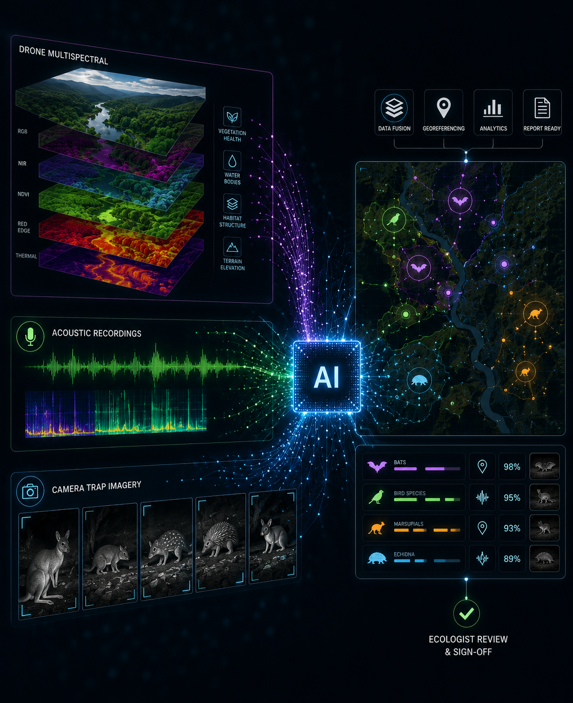
Raw field data from ARU networks, camera traps, and drone surveys is processed through a structured AI-assisted detection pipeline before it reaches the ecologist's desk.
Acoustic recordings are analysed using BirdNET, FrogID, and Kaleidoscope Pro for bat echolocation classification. Camera trap imagery is filtered through MegaDetector to remove blank frames, then passed through the AWC Australian Wildlife Classifier for species-level identification. All candidate detections are presented in a structured Timelapse review interface, organised by species, detection confidence, and GPS location, for verification by a qualified zoologist.
The result is a complete, georeferenced dataset: blank data removed, species detections flagged and spatially referenced, habitat layers fused, and the entire record structured for direct ecologist review and regulatory submission.
No species identification is finalised without zoologist sign-off. The AI pipeline is a preparation and efficiency tool, the ecologist remains the decision-maker on every record.
Where required, we can provide an ecological partner for report sign-off, or integrate directly with your existing ecological team.
Suitable for: complete fauna survey data packages for EIA submission, subcontracted data collection for ecological consultancies, mining company environmental compliance programmes.